New Commute Calculator tool From Our Research Committee Helps Riders See How Trips Will Be Impacted by Draft 1.0 of the Bus Line Redesign
Pittsburgh Regional Transit (PRT) is proposing a significant Bus Line Redesign that could dramatically change how transit riders travel across the County. We think it’s very important that transit riders have the ability to assess how the Bus Line Redesign (BLR) will impact our commute times. PRT does not provide a way to compare travel times under the current bus network to the proposed BLR Draft 1.0, although we at PPT believe that this is invaluable information for riders to consider.
Since BLR is still a draft, we urge transit riders and supporters to see how the BLR Draft 1.0 will impact your commutes and tell us about any changes that you see. Also give public comment to Pittsburgh Regional Transit before the deadline at the end of the month!
PPT’s Research Committee used our tool to model 21 example transit trips in Allegheny County to and from important neighborhoods and destinations to compare travel times: 19 of those 21 trips would take longer under the BLR Draft 1.0 than they do today under our current network, which is very concerning. Many of these trips are longer because they would require more transfers under the new proposal. You can see the math behind these example commute calculations here.
CLICK HERE TO JUMP to the 21 example commute trips!
USE OUR ADVOCATE COMMUTE TOOL: Compare how your current commute is impacted by Draft 1.0 of the Bus Line Redesign Proposal
People care how long their trip will take. It’s unfortunate that Pittsburgh Regional Transit doesn’t provide a way to measure how your commute time will change under their bus network proposal. Luckily, our Research Committee created a tool to let people do just that.
To make a commute time comparison between an existing PRT transit trip and the proposed Bus Line Redesign transit trip, follow these instructions:
- Identify Your Route: Choose the starting point (e.g., your neighborhood intersection) and destination (e.g., an intersection, a key location like a workplace, hospital, grocery store, or transit hub).
- Enter it in Google Maps: Input the starting point and destination in Google Maps and adjust the route’s path according to the actual route and turns that the current bus takes. It is IMPORTANT to map your current route using the “driving” function of Google Maps (NOT the “transit” function!), in order to have an apples to apples comparison of the current route(s) against the proposed Bus Line Redesign route(s). This is suggested because travel times for the proposed routes are not yet available. It should be noted that actual transit travel times will likely be longer.
- Record Travel Details using Current Routes: Note the total travel time, number of transfers, and any walking required.
- Walking times from your origin to the bus stop, from the bus stop to your destination, or between buses related to a transfer can be assessed using the Google Maps “walking” function.
- For all transfers you need to add a transfer time “penalty” that is equal to half of the frequency of the second or connecting route. So for instance, if you must make a transfer and the bus you are transferring onto comes once every 30 minutes, you should add a 15 minute transfer penalty to your total commute time. This penalty represents the average wait time related to the transfer.
- Repeat for Proposed Routes: Find routing information for proposed routes here: Bus Line Redesign | Engage PRT
Adjust your Google Maps input to reflect the new proposed route and again use the car or driving option, not the transit option to calculate times for the proposed trip. Using the driving option for both the current and proposed trip will ensure a fair comparison.
- Compare: Copy a table or create a table with columns for the current and proposed routes, listing travel time, transfers, and walking distance. Highlight any key differences.
For example, if you wanted to look into a trip between
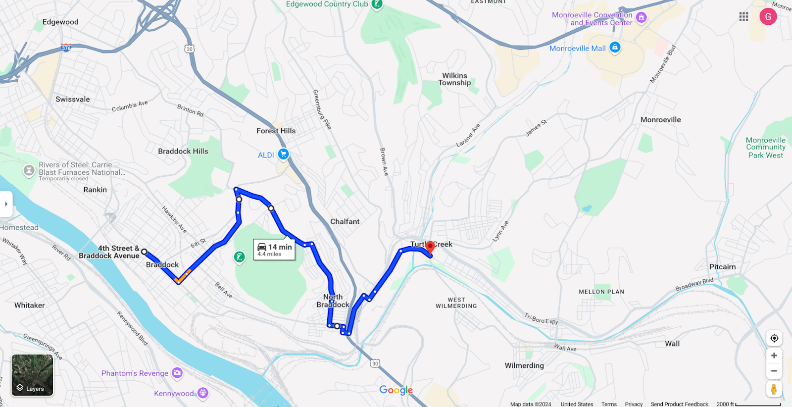
- 4th St. & Braddock Ave. (Apartments) to Walmart Supercenter, using the 59
- Enter it into Google Maps, using “driving” mode
- Record travel details – this route is a 20 minute “drive”
- Repeat with the proposed route
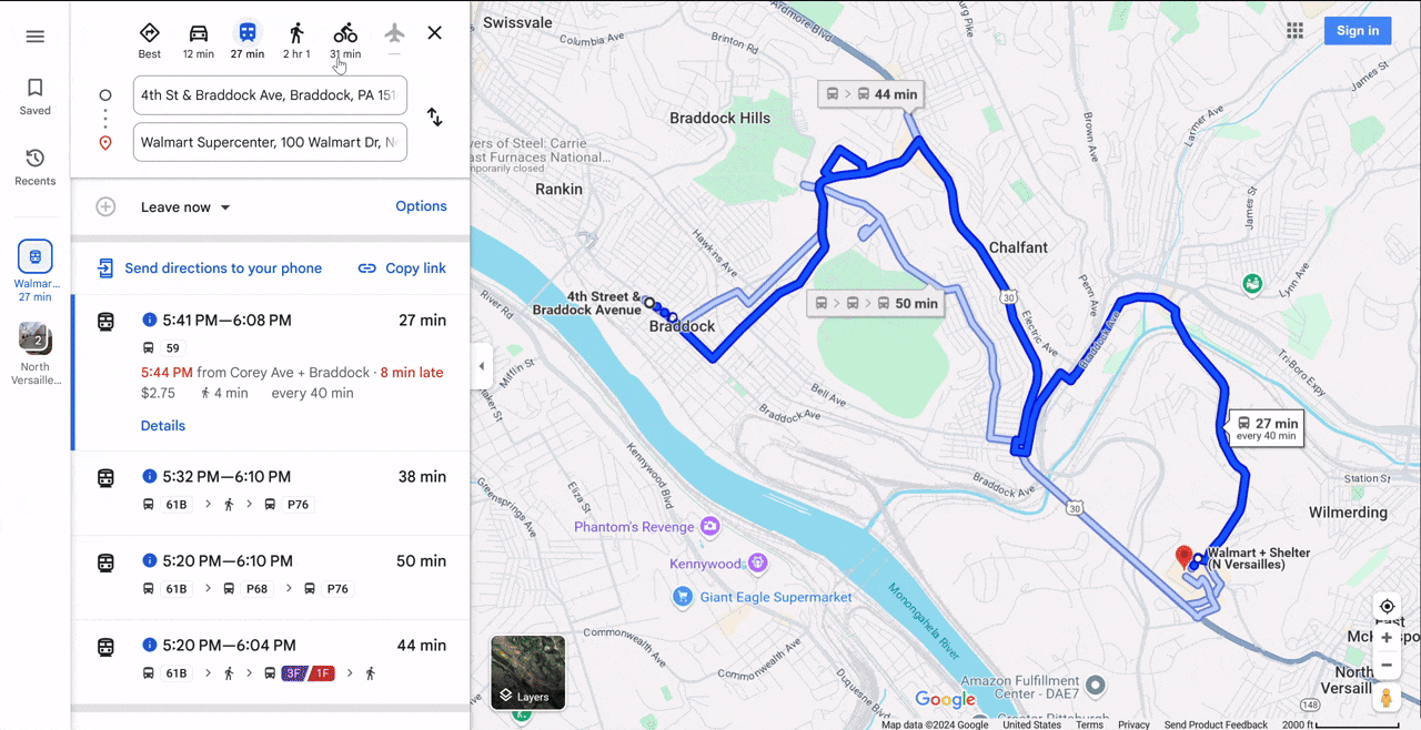
- Find the new route under Draft Network 1.0 – Find My Route
- The 59 Mon Valley is being split into several different routes. At this stretch, it is the N68 and N63.
- Enter each part of the new route into Google Maps, using “driving” mode

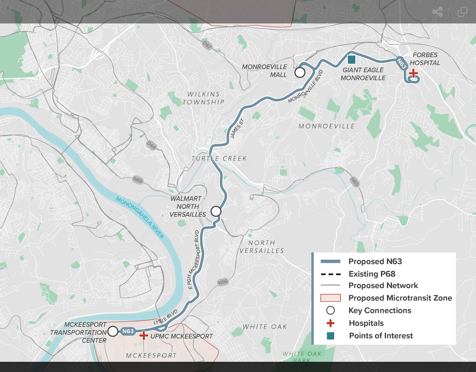
- Adding the two bus trips together gives a total bus travel time of 18 minutes. However, the new N63 will only have service every 60 minutes–so the transfer penalty will be 30 minutes. In total, the new travel time will be approximately 48 minutes.
- Fill in the chart with the information for your current route (on the left) and your new route (on the right) under the BLR proposal:

In this way, you are able to calculate the impact of the proposed changes in the BLR Draft 1.0 for yourself. It is important to remember that this does not have to be perfect. And if you need any help in doing this at any time, feel free to reach out to PPT and we will be glad to figure it out with you!
PPT’s Research Committee modeled Draft 1.0 of the Bus Line Redesign impacts on 21 different trips. Here’s the results:
- Hill District (Centre+Kirkpatrick) to Waterworks (Giant Eagle) – Travel Time Would be Shorter Under BLR Proposal
- Children’s Hospital (Penn+44th) to Shadyside (Fifth Avenue+S Highland) – Travel Time Would be Longer Under the BLR Proposal
- Lower Lawrenceville (Penn+Butler) to South Side (S 18th+Sarah) – Travel Time Would be Longer Under the BLR Proposal
- Trafford (5th+Brinton) to Monroeville (Forbes Hospital) – Travel Time Would be Much Longer Under the BLR Proposal
- Beltzhoover (Gearing+Chalfont) to Shadyside Hospital (Centre+Cypress) – Travel Time Would Be Similar Under the BLR Proposal with Additional Walking
- Squirrel Hill (Forbes+Murray) to Robinson Town Center (IKEA) – Travel Time Would be Longer Under the BLR Proposal
- Homewood (N Homewood+Frankstown) to Squirrel Hill (Allderdice High School) – Travel Time Would be Much Longer Under the BLR Proposal
- Kennedy (Pleasant Ridge) to Lawrenceville (Butler+46th) – Travel Time Would be Longer Under the BLR Proposal
- Natrona Heights (Freeport+Spring Hill) to Downtown (LIberty+Smithfield) – Travel Time Would be Significantly Longer Under the BLR Proposal
- Carnegie Mellon University (Forbes+Morewood) to CCAC Boyce Campus – Travel Time Would be Longer Under the BLR Proposal
- West View (Center+Harvard) to California Kirkbride District (Post Office) – Travel Time Would be Longer Under the BLR Proposal
- Shadyside (Giant Eagle Market District) to Blackridge (Laketon+Graham) – Travel Time Would be Much Longer Under the BLR Proposal
- Bridgeville (Bank+Lesnett) to South Side (E Carson+S 18th) – Travel Time Would be Much Longer Under the BLR Proposal
- Marshall Shadeland District (Brighton+Marshall) to North Hills (Passavant Hospital) – Travel Time Would be Slightly Longer under BLR Proposal
- Fairywood (Broadhead Fording+W Prospect) to VA Hospital (O’Hara Township) – Travel Time Would be Longer and More Complex Under BLR Proposal
- Hazelwood (Second+Johnston) to Penn State McKeesport – Travel Time Would be Significantly Longer and More Complex under BLR Proposal
- Glen Hazel (Broadview+Johnston) to Greenfield (Giant Eagle) – Travel Time Would be Longer under BLR Proposal
- Edgewood Town Center (Giant Eagle) to Wilkinsburg (Montier+Laketon) – Travel Time Would Be Similar Under the BLR Proposal
- Morningside (Jancey+Greenwood) to North Side (Allegheny General Hospital) – Travel Time Would be Longer under BLR Proposal
- Brookline (Chelton+Freedom) to Propel Braddock Hills High School – Travel Time Would be Shorter Under BLR Proposal
- Stanton Heights (Stanton+Hawthorne) to Bloomfield (West Penn Hospital) – Travel Time Would be Longer under BLR Proposal
Hill District (Centre+Kirkpatrick) to Waterworks (Giant Eagle) – Travel Time Would be Shorter Under BLR Proposal
Current route: 48 minutes | Proposed route: 40 minutes (8-minute improvement) Current Route: (82, 1) | Proposed Route: (D81)
Good news! Traveling from Centre & Kirkpatrick to Waterworks Giant Eagle would be slightly faster. The new route eliminates one transfer at Liberty+7th (Downtown), making your journey more straightforward.
Children’s Hospital (Penn+44th) to Shadyside (Fifth Avenue+S Highland) – Travel Time Would be Longer Under the BLR Proposal
Current route: 12 minutes | Proposed routes: 25 or 38 minutes (potential increase of 13-26 minutes).
Current Route: (64) | Proposed Routes: (N94, D73)
Caution! This route becomes more complicated. You’ll now need to walk more (from the Hospital to Liberty+Bloomfield Bridge) and make a transfer at Fifth+Shady which could significantly extend your travel time. You could walk from Fifth+Shady to Fifth+ S Highland to save the transfer time.
Lower Lawrenceville (Penn+Butler) to South Side (S 18th+Sarah) – Travel Time Would be Longer Under the BLR Proposal
Current route: 23 minutes | Proposed routes: 30 or 52 minutes.
Current Route: (54) | Proposed Routes: (O99, O47) or (D88, D51)
Significant variations here! One proposed route will have a 7-minute increase, while another adds nearly 30 minutes to your journey. Expect more walking and transfers at Fifth+Atwood (Oakland) or Smithfield+Fifth (Downtown) in both proposed scenarios.
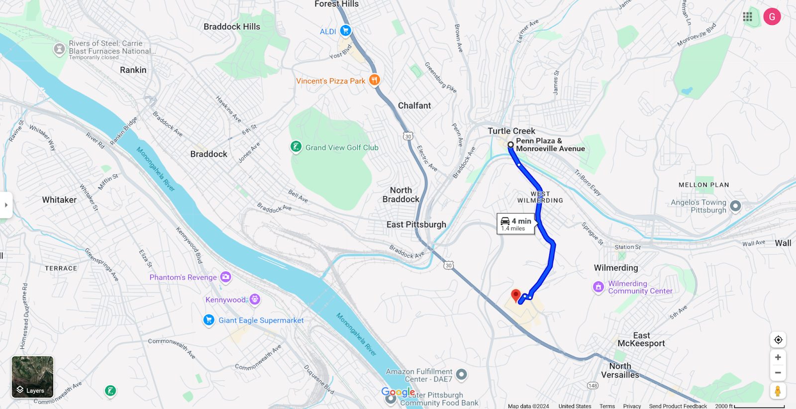
Trafford (5th+Brinton) to Monroeville (Forbes Hospital) – Travel Time Would be Much Longer Under the BLR Proposal
Current route: 11 minutes | Proposed route: 88 minutes (an extraordinary 77-minute increase).
Current Route: (69) | Proposed Route: (N65, N63)
Major Concern! This route sees a dramatic change. The new route involves a walk from Trafford to Haymaker Village and a transfer at North Versailles Walmart. The required and significant walking (due to the removal of bus service in Trafford) will turn a quick trip into a lengthy journey.
Beltzhoover (Gearing+Chalfont) to Shadyside Hospital (Centre+Cypress) – Travel Time Would Be Similar Under the BLR Proposal with Additional Walking
Current route: 46 minutes | Proposed routes: 49 or 52 minutes.
Current Routes: (44, 82) | Proposed Routes: (N84, D82) or (RED, D82)
While only slightly longer overall, there is significant additional walking. You will still have one transfer.
Squirrel Hill (Forbes+Murray) to Robinson Town Center (IKEA) – Travel Time Would be Longer Under the BLR Proposal
Current route: 61 minutes | Proposed routes: 78 or 85 minutes (an increase of 17-24 minutes).
Current Routes: (61C, 28X) | Proposed Routes: (X50, D29) or (X50, D25)
Longer journey ahead! The new routes involve a Downtown transfer and slightly longer walking distances, potentially making your commute longer and less convenient.
Homewood (N Homewood+Frankstown) to Squirrel Hill (Allderdice High School) – Travel Time Would be Much Longer Under the BLR Proposal
Current route: 16 minutes | Proposed route: 49 minutes (33-minute increase).
Current Route: (74) | Proposed Routes: (N92, N94)
Significant time increase! The new route requires a transfer at Penn+Shady which will add more walking, and substantially more time to reach your destination.
Kennedy (Pleasant Ridge) to Lawrenceville (Butler+46th) – Travel Time Would be Longer Under the BLR Proposal
Current route: 47 minutes | Proposed routes: 57 or 66 minutes (10-19 minute increase).
Current Routes: (22, 91) | Proposed Routes: (N22, GREEN, D91) or (N22, D21, D91)
Longer journey ahead! The new routes involve more walking, an additional transfer and more complex navigation.
Natrona Heights (Freeport+Spring Hill) to Downtown (LIberty+Smithfield) – Travel Time Would be Significantly Longer Under the BLR Proposal
Current route: 54 minutes | Proposed routes: 89 or 104 minutes (an extraordinary 35-50 minute increase).
Current Route: (P10) | Proposed Routes: (N1, PURPLE) or (N1, D5)
Major Time Increase! Riders will now face a transfer either at East Liberty Station or Harmar Garage, significantly longer travel times, and more complicated routes.
Carnegie Mellon University (Forbes+Morewood) to CCAC Boyce Campus – Travel Time Would be Longer Under the BLR Proposal
Current route: 50 minutes | Proposed routes: 65 minutes (15-minute increase)
Current Route: (67) | Proposed Routes: (D70, N72) or (D70, N77)
Travel Times Will Increase. The route requires a transfer at Wilkinsburg Station and walking, with both possible options taking roughly the same time.
West View (Center+Harvard) to California Kirkbride District (Post Office) – Travel Time Would be Longer Under the BLR Proposal
Current route: 17 minutes | Proposed route: 33 minutes (nearly doubled travel time).
Current Route: (13) | Proposed Route: (N17, D16)
Significant Time Increase! The new route introduces a transfer at Lincoln+Balph and additional walking.
Shadyside (Giant Eagle Market District) to Blackridge (Laketon+Graham) – Travel Time Would be Much Longer Under the BLR Proposal
Current route: 19 minutes | Proposed route: 52 minutes (33-minute increase).
Current Route: (P78) | Proposed Route: (PURPLE, N77)
Major Time Increase! Transfer at Wilkinsburg Station will substantially increase travel time.
Bridgeville (Bank+Lesnett) to South Side (E Carson+S 18th) – Travel Time Would be Much Longer Under the BLR Proposal
Current route: 43 minutes | Proposed route: 63 minutes (20-minute increase).
Current Routes: (41, 51) | Proposed Route: (N33, GREEN, D51)
Significant commute time Increase! There will be an additional transfer, one at Carnegie Station and the second at Sixth+Wood complicating what was previously a more direct journey.
Marshall Shadeland District (Brighton+Marshall) to North Hills (Passavant Hospital) – Travel Time Would be Slightly Longer under BLR Proposal
Current route: 68 minutes | Proposed route: 74 minutes (6-minute increase).
Current Routes: (16, 12) | Proposed Route: (D16, D2)
Small Increase in Commute Time. There would be a change to the commute time in this scenario, and a change in the transfer location.
Fairywood (Broadhead Fording+W Prospect) to VA Hospital (O’Hara Township) – Travel Time Would be Longer and More Complex Under BLR Proposal
Current route: 81 minutes | Proposed routes: 96 or 98 minutes (15-17 minute increase).
Current Routes: (27, 91) | Proposed Routes: (N22, GREEN, D5, N92) or (N22, GREEN, PURPLE, N92)
Longer Journey. Requires two additional transfers (or four buses), increased walking, and more complex routing.
Hazelwood (Second+Johnston) to Penn State McKeesport – Travel Time Would be Significantly Longer and More Complex under BLR Proposal
Current route: 23 minutes | Proposed route: 65 minutes (42-minute increase).
Current Route: (56) | Proposed Route: (D52, X50, N56)
Significant Time Increase! This would be a substantially longer trip with two transfers, one at E 8th+Ann (Homestead) and the other at Lysle+Evans (McKeesport).
Glen Hazel (Broadview+Johnston) to Greenfield (Giant Eagle) – Travel Time Would be Longer under BLR Proposal
Current route: 10 minutes | Proposed routes: 13 or 36 minutes (slight to significant increase).
Current Route: (93) | Proposed Routes: (O53, D44) or (O53, X50)
Mixed Results: One proposed route requires a transfer at Browns Hill+Imogene (with the need to cross busy Browns Hill Road), while the other adds substantial time requiring a transfer at Hazelwood+Osprey.
Edgewood Town Center (Giant Eagle) to Wilkinsburg (Montier+Laketon) – Travel Time Would Be Similar Under the BLR Proposal
Current and Proposed route: 41 minutes.
Current Routes: (71, 79) | Proposed Route: (X61, X60, N79)
No additional time, but an additional transfer. Despite additional walking and two transfers, one at Forbes+S Braddock (Frick Park) and the other at Penn+Center (Wilkinsburg), the overall travel time remains the same.
Morningside (Jancey+Greenwood) to North Side (Allegheny General Hospital) – Travel Time Would be Longer under BLR Proposal
Current route: 40 minutes | Proposed routes: 49 or 53 minutes (9-13 minute increase).
Current Routes: (87, 54) | Proposed Routes: (D96, D5) or (D96, D12)
Longer Trip Ahead! This commute becomes more complex and longer with additional walking and new transfer locations depending on the chosen option, one at Freeport+Western (Aspinwall) or the other at Liberty+7th (Downtown).
Brookline (Chelton+Freedom) to Propel Braddock Hills High School – Travel Time Would be Shorter Under BLR Proposal
Current route: 81 minutes | Proposed route: 75 minutes (6-minute decrease).
Current Routes: (39, P68) | Proposed Route: (D39, D64)
Slight commute time improvement. An instance of travel time becoming shorter, but there would be increased walking time.
Stanton Heights (Stanton+Hawthorne) to Bloomfield (West Penn Hospital) – Travel Time Would be Longer under BLR Proposal
Current route: 12 minutes | Proposed routes: 29 or 32 minutes (17-20 minute increase).
Current Route: (87) | Proposed Routes: (D87, D88) or (D87, N79)
Significant Time Increase! A transfer would be required either at Penn+Negley or at N Negley+East Liberty Boulevard and additional walking will increase travel time.
Our conclusion? Riders have reason to be concerned.
In the 21 examples the proposed Bus Line Redesign Draft 1.0 predominantly increases travel times, introduces more transfers, and requires additional walking. Under Pittsburgh Regional Transit’s Bus Line Redesign (BLR) Draft 1.0, many riders could expect to have longer, more complicated commutes. We recommend reviewing specific changes to the routes you ride to understand how your daily travel might be impacted. We highly encourage leaving a comment on the Bus Line Design website Bus Line Redesign | Engage PRT or by calling PRT’s Customer Service Line at (412) 442-2000 or by sending an email at BusLineRedesign@RidePRT.org to ensure that your feedback is heard by PRT.